 |
Port-Orford
is located in southwestern Oregon along the Pacific coast, 27 miles from the town of Gold Beach. Historical Port Orford started as a fishing and lumber port, and that remains a primary industry of the town today. It is one of the oldest towns in Coos and Curry counties and one of Oregon's only true ocean harbors. Port Orford has spectacular ocean views and is a popular spot for fishing and crabbing, scuba diving, whale watching and wind surfing. The Elk and Sixes Rivers, just a few miles north of Port Orford are well known for their trout and salmon fishing and rafting. Float trips are also available on the rivers. Nine miles north of Port Orford stands Cape Blanco Lighthouse, the oldest standing lighthouse on the Oregon coast, which offers wonderful photographic opportunities. And, Cape Blanco State Park has fishing, hiking, camping and picnicking for visitors. Other points of interests near Port Orford include Battle Rock State Park, the Prehistoric Gardens, Humbug State Park and the black sands of Humbug Beach. A three-mile hike up Humbug Mountain is well worth the effort as it passes through a beautiful virgin forest that includes a grove of the rare Port Orford cedar. .

|
Port Orford Vacation Rentals
|

|
|
|
|
|
Port Orford Hotels and Resorts
|
|
|
| | | Hotels & Motels |
| Sand'n Sea Motel | 29362 Ellensburg Ave | Gold Beach, OR | 24.2 mi. | (800) 808-7263 | | Shore Cliff Inn | 29346 Ellensburg | Gold Beach, OR | 24.2 mi. | (888) 663-0608 | | Gold Beach Beach | 29232 S Ellensburg Ave | Gold Beach, OR | 24.4 mi. | (541) 247-7066 |

|
Port Orford Weather & Climate
|

|
|
|
The Brookings-Harbor Area, including Gold Beach and the other nearby coastal towns, is known as the "Banana Belt" of the Pacific Northwest. While most of the Oregon coast is blanketed with clouds and fog, the Banana Belt is usually sunny. During the summer months, this area of the coast may be cool and foggy in the mornings, but is soon nice and sunny. Temperatures in the summer are in the upper 60s or low 70s and drop into the mid-50s at night. Rainfall is rare during the summer months in the Banana Belt. During the wintertime, it's another story, with about 80 inches of rainfall per year from November through April. Temperatures in winter average in the 50s to 60s, but it's not uncommon for the thermometer to soar into the 70s or even low 80s. Snow and sleet are rare in this region, and Mt. Emily and Cape Blanco shelter the Banana Belt from high winds.
|
| Month |
High Temp |
Low Temp |
Rainfall |
Ocean Temp |
| January |
53°F |
39°F |
11.40 in. |
50°F |
| February |
54°F |
41°F |
9.57 in. |
50°F |
| March |
55°F |
41°F |
9.69 in. |
50°F |
| April |
57°F |
42°F |
5.75 in. |
50°F |
| May |
60°F |
46°F |
3.85 in. |
51°F |
| June |
64°F |
49°F |
2.11 in. |
51°F |
| July |
67°F |
52°F |
0.63 in. |
51°F |
| August |
68°F |
52°F |
1.20 in. |
52°F |
| September |
67°F |
50°F |
2.02 in. |
53°F |
| October |
63°F |
46°F |
4.86 in. |
52°F |
| November |
56°F |
43°F |
10.89 in. |
52°F |
| December |
53°F |
39°F |
12.24 in. |
51°F |

|
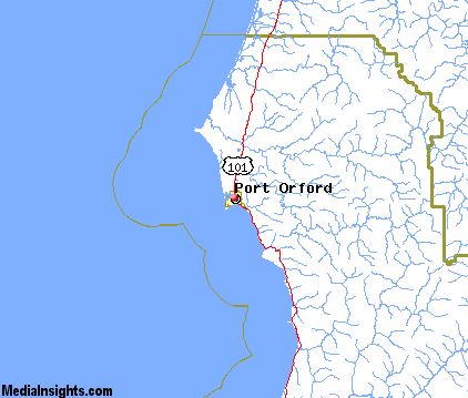
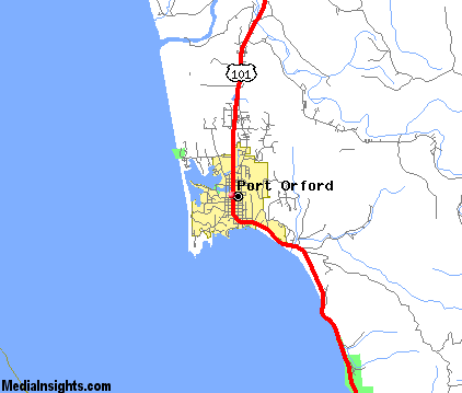
Port Orford Map & Transportation
|

|
|
 |
|
|
| Click each thumbnail image to enlarge. |
 |
|
 |
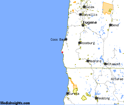 |
The closest airports in the area are the Cape Blanco State airport (5S6) located about 7 miles north of Port Orford in Denmark, Oregon, the North Bend Municipal airport (OTH) located approximately 47 miles northeast of Port Orford in North Bend, Oregon, the Illinois Valley airport (3S4) located roughly 61 miles southeast of Port Orford in Cave Junction, Oregon, and finally Jack Mc Namara Field (CEC) located around 68 miles south of Port Orford in Crescent City, California.
|

|
Port Orford Attractions
|

|
|
| | | Golf Courses |
| Cedar Bend Golf Club | Gold Beach | OR | 24.4 mi. | | | Bandon Dunes | Bandon | OR | 25.9 mi. | | | Bandon Face Rock Golf Course | Bandon | OR | 25.9 mi. | |
| | | Ski Areas |
| Mount Ashland | Ashland | OR | 99.0 mi. | | | Willamette Pass | Eugene | OR | 114.6 mi. | |
| | | State Parks |
| Paradise Point State Park | | OR | 0.9 mi. | | | Port Orford Heads State Park | | OR | 0.9 mi. | | | Cape Blanco State Park | | OR | 5.9 mi. | | | Humbug Mountain State Park | | OR | 5.9 mi. | | | Port Orford Cedar Forest State Park | | OR | 6.4 mi. | | | Floras Lake State Park | | OR | 7.7 mi. | | | Sisters Rock State Park | | OR | 12.3 mi. | | | Geisel Monument State Park | | OR | 18.5 mi. | | | Otter Point State Park | | OR | 20.4 mi. | | | Bandon State Park | | OR | 21.0 mi. | | | Albert H Powers Memorial State Park | | OR | 23.6 mi. | | | Face Rock State Park | | OR | 24.4 mi. | | | Coquille Myrtle Grove State Park | | OR | 24.9 mi. | | | Buena Vista State Park | | OR | 26.5 mi. | | | Hoffman Memorial State Park | | OR | 27.6 mi. | | | Bullards Beach State Park | | OR | 28.1 mi. | | | Cape Sebastian State Park | | OR | 29.3 mi. | | | Pistol River State Park | | OR | 33.5 mi. | | | Secen Devils State Park | | OR | 33.7 mi. | | | Cape Arago State Park | | OR | 38.4 mi. | |
| | | Museums |
| Coos Art Museum | Coos Bay | OR | 44.9 mi. | (Art) |
| | | Zoos and Aquariums |
| Wildlife Safari | Winston | OR | 60.7 mi. | |
Notice a problem with the information on this page? Please notify us.
|
Disclaimer: We recommend you conduct your own research regarding all accomodations and attractions found on this website. The distances shown on this website are straight-line distances as the crow flies. The road distance may be considerably longer. You assume all liability for use of any information found on this website. No information is confirmed or warranted in any way. By using our services you agree to the terms and conditions of this disclaimer.
|
| We are the #1 site for your Oregon Vacations presenting Oregon vacation rentals, hotels, weather and map for each city. |
Oregon Vacations .com
©1997-2025 All Rights Reserved.
|
|