 |
Shady-Cove
is a picturesque town that bills itself as "The Jewel of the Upper Rogue." The mighty Rogue River winds its way through this small town, where white water rafting; boat and river tours and excellent fishing opportunities abound. Located along Highway 62 on the Rogue-Umpqua Scenic Byway in northern Jackson County, the town of Shady Cove is less than an hours drive to Crater Lake National Park. The town of Shady Cove is, in fact, the closest full service community to the National Park, and although small in size (population only 2450,) it has amenities and services you would expect to find in a much larger city. Hiking trails and bike routes along the Upper Rogue near Shady Cove take visitors through countryside filled with waterfalls, wildflowers and wildlife. The town has long been known for its' record breaking salmon and steelhead fishing, as well as rafting and its Robert Trent Jones championship 18-hole golf course. Several snowmobile parks in the area make Shady Cove a year round vacation destination. The town also holds several special events throughout the year, such as their annual 4th of July Celebration at Shady Cove Park that includes a salmon barbecue. There is also a Wildflower Show, usually held the first weekend of May and an annual Spam Parade and BBQ in August. Other nearby attractions include Lost Creek Lake, Casey State Park and Stewart State Park.

|
Shady Cove Vacation Rentals
|

|
|
|
|
|
Shady Cove Hotels and Resorts
|
|
|
| | | Hotels & Motels |
| The Edgewater Inn | 7800 Rogue River Dr | Shady Cove, OR | | (541) 878-3171 | | Holiday Inn Express Hotel & Suites | 285 Penninger St | Central Point, OR | 16.9 mi. | (541) 423-1010 | | Courtyard By Marriott Medford Airport | 600 Airport Rd | Medford, OR | 17.0 mi. | (541) 772-5656 | | Motel 6 | 2400 Biddle Rd | Medford, OR | 18.2 mi. | (541) 779-0550 | | Fairfield Inn And Suites By Marriott | 1777 Larue Dr | Central Point, OR | 18.3 mi. | (541) 665-4141 | | Rogue Regency Inn | 2300 Biddle Rd | Medford, OR | 18.3 mi. | (541) 770-1234 | | Comfort Inn North | 2280 Biddle Rd | Medford, OR | 18.4 mi. | (541) 772-9500 | | Ramada & Convention Center | 2250 Biddle Rd | Medford, OR | 18.4 mi. | (541) 779-3141 | | Hampton Inn | 1122 Morrow Rd | Medford, OR | 18.5 mi. | (541) 779-0660 | | Windmill Inn Of Medford | 1950 Biddle Rd | Medford, OR | 18.5 mi. | (800) 547-4747 | | Shilo Inn Medford | 2111 Biddle Rd | Medford, OR | 18.7 mi. | (541) 641-6565 | | Red Lion Hotel Medford | 200 N Riverside | Medford, OR | 19.7 mi. | (541) 779-5811 | | Best Western Pony Soldier Inn Medford | 2340 Crater LK Hwy | Medford, OR | 19.9 mi. | (541) 779-2011 | | Candlewood Suites | 3548 Heathrow Way | Medford, OR | 19.9 mi. | (541) 772-2800 | | Red Carpet Inn | 525 S Riverside | Medford, OR | 20.2 mi. | (541) 772-6133 | | Days Inn Of Medford Or | 850 Alba Dr | Medford, OR | 20.4 mi. | (541) 779-6730 | | Motel 6 #89 | 950 Alba Dr | Medford, OR | 20.4 mi. | (541) 773-4290 | | Travelodge Of Medford | 954 Alba Dr | Medford, OR | 20.4 mi. | (541) 773-1579 | | Best Western Horizon Inn | 1154 Barnett Rd | Medford, OR | 20.5 mi. | (541) 779-5085 | | Comfort Inn South | 60 E Stewart Ave | Medford, OR | 20.7 mi. | (541) 772-8000 | | The Stage Lodge Motel | 830 N 5TH St | Jadksonville, OR | 21.5 mi. | (541) 899-3953 | | Holiday Inn Express | 1501 S Pacific Hwy | Medford, OR | 22.1 mi. | (541) 732-1400 | | Super 8 | 300 Pear Tree Ln | Phoenix, OR | 22.8 mi. | (541) 535-4445 | | Econo Lodge | 50 Lowe Rd | Ashland, OR | 26.8 mi. | (541) 482-4700 | | La Quinta Inn & Suites | 434 Valley View Rd | Ashland, OR | 26.9 mi. | (541) 482-6932 | | Best Western Inn | 111 Ne Agness Ave | Grants Pass, OR | 27.5 mi. | (541) 476-1117 | | Holiday Inn Express Grants Pass | 105 Ne Agness Ave | Grants Pass, OR | 27.5 mi. | (541) 471-6144 | | La Quinta Inn & Suites | 243 Ne Morgan Ln | Grants Pass, OR | 27.8 mi. | (541) 472-1808 | | Super 8 Motel | 1949 Ne 7TH St | Grants Pass, OR | 27.9 mi. | (541) 474-0888 | | Comfort Inn | 1889 Ne 6TH St | Grants Pass, OR | 28.0 mi. | (541) 479-8301 | | Grants Pass Shilo Inn | 1880 NW 6TH St | Grants Pass, OR | 28.0 mi. | (541) 479-8391 | | Grants Pass Travelodge | 1950 NW Vine | Grants Pass, OR | 28.0 mi. | (541) 479-6611 | | Sweet Breeze Inn | 1627 NE 6th St | Grants Pass, OR | 28.1 mi. | (541) 471-4434 | | Rodeway Inn | 1253 NE 6th St | Grants Pass, OR | 28.3 mi. | (541) 479-2952 | | Plaza Inn & Suites At Ashland Creek | 98 Central Ave | Ashland, OR | 28.8 mi. | (541) 488-8900 | | Best Western Inn At The Rogue | 8959 Rogue Riv Hwy | Grants Pass, OR | 28.8 mi. | (541) 582-2200 | | Motel 6 #253 | 1800 North East Seventh | Grants Pass, OR | 28.8 mi. | (541) 474-1331 | | Ashland Springs Hotel | 212 East Main St | Ashland, OR | 29.1 mi. | (541) 488-1700 | | Green Springs Inn | 11470 Hwy 66 | Ashland, OR | 29.2 mi. | (541) 482-0614 | | Our Shepherd's Inn | 159 Bloom Rd | Wolf Creek, OR | 29.7 mi. | (541) 866-2501 |
| | | Bed & Breakfast |
| Ahlf House Bed & Breakfast | 762 NW 6TH St | Grants Pass, OR | 28.5 mi. | (541) 474-1374 |

|
Shady Cove Weather & Climate
|

|
|
|
Southern Oregon near the Rogue River, lies in the heart of a region where three mountain ranges meet. These three ranges - The Cascades, the Siskiyous and the Coast Range- meet in the Rogue Valley and create a pleasant climate. The area generally sees warm, dry summers with cool evenings, and moderate winters. December is often the wettest month and average annual precipitation is less than 30 inches. This region is located in the "sun belt" of southern Oregon, with the most sunny days of any area in the state. This area also boasts a gentle wind velocity, averaging only 3.2 mph. Plan on warm, sunny days with cool, dry evenings from mid-May through mid-September. Snow flurries are possible in the wintertime but usually do not stick around for long.
|
| Month |
High Temp |
Low Temp |
Rainfall |
Ocean Temp |
| January |
47°F |
28°F |
4.88 in. |
- |
| February |
52°F |
30°F |
4.02 in. |
- |
| March |
57°F |
32°F |
3.78 in. |
- |
| April |
63°F |
36°F |
2.50 in. |
- |
| May |
71°F |
41°F |
2.04 in. |
- |
| June |
79°F |
46°F |
1.00 in. |
- |
| July |
88°F |
50°F |
0.55 in. |
- |
| August |
88°F |
49°F |
0.69 in. |
- |
| September |
82°F |
43°F |
1.11 in. |
- |
| October |
70°F |
36°F |
2.41 in. |
- |
| November |
52°F |
32°F |
5.32 in. |
- |
| December |
46°F |
28°F |
5.45 in. |
- |

|
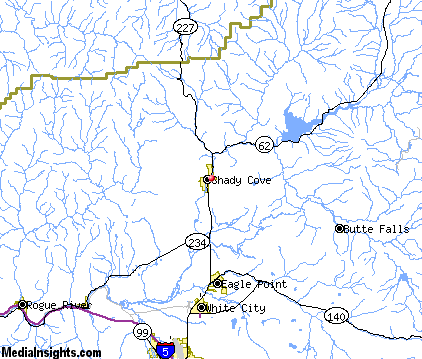
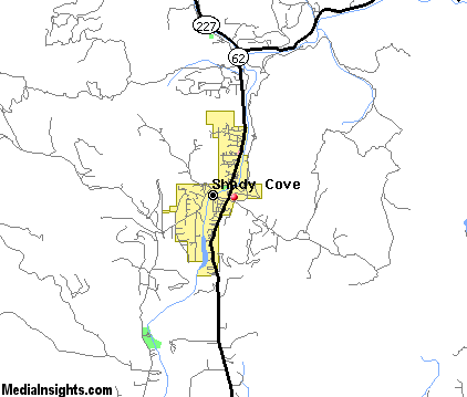
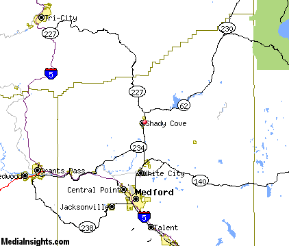
Shady Cove Map & Transportation
|

|
|
 |
|
|
| Click each thumbnail image to enlarge. |
 |
|
 |
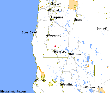 |
The closest airports in the area are the Rogue Valley International Medford airport (MFR) located about 16 miles south of Shady Cove in Medford, Oregon, the Illinois Valley airport (3S4) located approximately 56 miles southwest of Shady Cove in Cave Junction, Oregon, the Siskiyou County airport (SIY) located roughly 59 miles south of Shady Cove in Montague, California, and finally the Klamath Falls airport (LMT) located around 63 miles southeast of Shady Cove in Klamath Falls, Oregon.
|

|
Shady Cove Attractions
|

|
|
| | | Golf Courses |
| Eagle Point Golf Course | Eagle Point | OR | 9.8 mi. | | | Stone Ridge Golf Club | Eagle Point | OR | 9.8 mi. | | | Bear Creek Golf Course & Range | Medford | OR | 20.3 mi. | | | Cedar Links Golf Club | Medford | OR | 20.3 mi. | | | Quail Point Golf Course | Medford | OR | 20.3 mi. | | | Stewart Meadows | Medford | OR | 20.3 mi. | | | Applegate Golf | Grants Pass | OR | 28.8 mi. | | | Colonial Valley Golf Course | Grants Pass | OR | 28.8 mi. | | | Dutcher Creek Golf Course | Grants Pass | OR | 28.8 mi. | | | Grants Pass Golf Club | Grants Pass | OR | 28.8 mi. | | | Red Mountain Golf Course | Grants Pass | OR | 28.8 mi. | |
| | | Ski Areas |
| Mount Ashland | Ashland | OR | 29.2 mi. | | | Willamette Pass | Eugene | OR | 100.6 mi. | |
| | | State Parks |
| Casey State Park | | OR | 7.0 mi. | | | Joseph H Stewart State Park | | OR | 11.3 mi. | | | TouVelle State Park | | OR | 12.3 mi. | | | Ben Hur Lampman State Park | | OR | 17.9 mi. | | | Prospect State Park | | OR | 18.6 mi. | | | Valley of the Rogue State Park | | OR | 21.7 mi. | | | Canyon Creek Forest State Park | | OR | 29.1 mi. | | | Stage Coach Forest State Park | | OR | 29.1 mi. | | | Wolf Creek Inn State Park | | OR | 29.9 mi. | | | Tub Springs State Park | | OR | 39.7 mi. | |
| | | Zoos and Aquariums |
| Wildlife Safari | Winston | OR | 46.6 mi. | |
Notice a problem with the information on this page? Please notify us.
|
Disclaimer: We recommend you conduct your own research regarding all accomodations and attractions found on this website. The distances shown on this website are straight-line distances as the crow flies. The road distance may be considerably longer. You assume all liability for use of any information found on this website. No information is confirmed or warranted in any way. By using our services you agree to the terms and conditions of this disclaimer.
|
| We are the #1 site for your Oregon Vacations presenting Oregon vacation rentals, hotels, weather and map for each city. |
Oregon Vacations .com
©1997-2025 All Rights Reserved.
|
|