 |
Zigzag
is the name of an unincorporated tourist-oriented community within the Mt. Hood region, located along Highway 26 between the towns of Rhododendron and Welches. One of the ranger stations for the Mount Hood National Forest is located in Zigzag, found inside a cabin that was built in the early 1900s and now listed on the National Register of Historic Places. The town of Rhododendron shares the same zip code with Zigzag, and the name is also applied to the crystal clear Zigzag River and the Zigzag Glacier on top of Mt. Hood. The National Forest extends south from the Columbia River Gorge across more than sixty miles of gorgeous forested mountains, lakes and streams to the Olallie Scenic Area, which is a high lake basin beneath Mt. Jefferson that provides a primitive recreational experience. Altogether, the Mt. Hood National Forest encompasses 1,067, 043 acres. Of the many activities to enjoy in the Zigzag area, the following are some of the most popular; hiking, fishing, boating, camping, and wintertime skiing and snowboarding. Snowmobiles are not allowed in the wilderness areas. Berry picking and mushroom hunting are also popular. Attractions within the Mt. Hood region include Timberline Lodge on top of Mt. Hood, Lost Lake, Rock Creek Reservoir and portions of the Old Oregon Trail. A word of caution if you are visiting in the wintertime - weather conditions can change rapidly on the mountain.

|
Zigzag Vacation Rentals
|

|
|
|
|
|
Zigzag Hotels and Resorts
|
|
|
| | | Hotels & Motels |
| Resort At The Mountain | 68010 E Fiarway Ave | Welches, OR | 1.4 mi. | (503) 622-3101 | | MT Hood Inn | 87450 E Government CP Loop | Government Camp, OR | 9.6 mi. | (503) 272-3205 | | Timberline Lodge | Timberline Rd | Government Camp, OR | 9.6 mi. | (503) 622-0715 | | Timberline Lodge/ski Area | Ski Area | Government Camp, OR | 9.6 mi. | (503) 272-3706 | | Best Western Sandy Inn | 37465 Hwy 26 East | Sandy, OR | 15.9 mi. | (503) 668-7100 | | Alton L Collins Retreat Center | 32867 Se Hwy 211 | Eagle Creek, OR | 20.2 mi. | (503) 637-6411 | | Bonneville Hot Springs Resort | 1252 Cascade Dr | N Bonneville, WA | 21.4 mi. | (509) 427-7767 | | Best Western Columbia River Inn | 735 Wanapa St | Cascade Locks, OR | 22.7 mi. | (541) 374-8777 | | Timbers | 200 SW Cascade Ave | Stevenson, WA | 24.2 mi. | (509) 427-5656 | | Econo Lodge | 40 Ne 2ND St | Stevenson, WA | 24.5 mi. | (509) 427-5628 | | Skamania Lodge | 1131 Skamania LDG Way | Stevenson, WA | 24.5 mi. | (509) 427-2635 | | Howard Johnson Inn | 1572 NE Burnside Rd | Gresham, OR | 25.5 mi. | (503) 666-9545 | | Quality Inn Gresham | 1545 Ne Burnside St | Gresham, OR | 25.5 mi. | (503) 666-9545 | | Holiday Inn Portland/Gresham | 2752 NE Hogan Dr | Gresham, OR | 25.7 mi. | (503) 907-1777 | | Best Western Pony Soldier Inn Gresham | 1060 E Cleveland Ave | Gresham, OR | 25.8 mi. | (503) 665-1591 | | Days Inn & Suites | 24124 Se Stark St | Gresham, OR | 25.8 mi. | (800) 788-8924 | | Comfort Inn & Suites Troutdale | 477 NW Phoenix Dr | Troutdale, OR | 25.8 mi. | (503) 669-6500 | | Burns West Motel | 790 NW Frontage | Troutdale, OR | 25.9 mi. | (503) 667-6212 | | Inn America A Budget Motel | 1000 NW Graham Rd | Troutdale, OR | 25.9 mi. | (800) 469-4667 | | Canby Inn | 463 SW First Ave Hwy 99e | Gresham, OR | 26.0 mi. | (503) 266-5400 | | Mcmenamins Edgefield | 2126 SW Halsey St | Troutdale, OR | 26.2 mi. | (503) 669-8610 | | Best Western Rama Inn | 23525 Ne Halsey | Troutdale, OR | 26.8 mi. | (503) 491-9700 | | Wood Village Shilo Inn | 2522 Ne 238TH Dr | Wood Village, OR | 26.8 mi. | (503) 641-6565 | | Econo Lodge | 18323 Se Stark St | Portland, OR | 28.5 mi. | (800) 426-3666 | | Travelers Inn & Suites | 121 Ne 181ST Ave | Portland, OR | 28.7 mi. | (503) 661-5100 | | Comfort Suites | 1477 Ne 183RD Ave | Gresham, OR | 29.0 mi. | (877) 771-7769 | | Four Points Hotel By Sheraton Portland East | 1919 Ne 181ST Ave | Portland, OR | 29.1 mi. | (503) 491-1818 | | Days Inn Portland East/Gresham | 2261 NE 181st Ave | Portland, OR | 29.3 mi. | (503) 618-8400 | | Hawthorn Inn & Suites | 2323 Ne 181ST Ave | Portland, OR | 29.3 mi. | (503) 492-4000 | | Extended Stay America | 17777 NE Sacramento St | Portland, OR | 29.4 mi. | (503) 661-0226 | | Hampton Inn | 3039 Ne 181ST Ave | Portland, OR | 29.4 mi. | (503) 669-7000 |

|
Zigzag Weather & Climate
|

|
|
|
Northwest Oregon, near Portland, enjoys a mild climate with only occasional severe weather elements such as tornadoes, hailstorms, or high winds. The single most important factor in the climate is the Pacific Ocean. Due to the normal movement of air masses from west to east, most of the systems moving across Oregon have been modified extensively after traveling over the Pacific Ocean. As a result, winter temperatures and summer maximum temperatures are greatly moderated. However, the northwestern corner of the state does receive abundant rainfall. Near the coast, the average annual snowfall is only one to three inches, with many years in which there is no measurable amount at all. Hailstorms occur each year, but are generally light and cover small areas. The north coastal area has the least amount of sunshine each year, while the southeast corner of the state has the most.
|
| Month |
High Temp |
Low Temp |
Rainfall |
Ocean Temp |
| January |
35°F |
24°F |
12.86 in. |
- |
| February |
38°F |
25°F |
10.23 in. |
- |
| March |
41°F |
27°F |
8.50 in. |
- |
| April |
45°F |
30°F |
7.54 in. |
- |
| May |
52°F |
35°F |
5.20 in. |
- |
| June |
59°F |
40°F |
3.80 in. |
- |
| July |
67°F |
46°F |
1.36 in. |
- |
| August |
68°F |
46°F |
1.61 in. |
- |
| September |
62°F |
42°F |
3.60 in. |
- |
| October |
53°F |
36°F |
6.51 in. |
- |
| November |
40°F |
29°F |
13.13 in. |
- |
| December |
35°F |
24°F |
14.38 in. |
- |

|
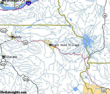
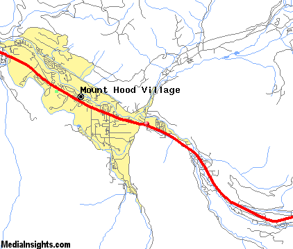
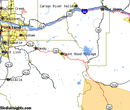
Zigzag Map & Transportation
|

|
|
 |
|
|
| Click each thumbnail image to enlarge. |
 |
|
 |
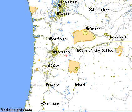 |
The closest airports in the area are the Portland Troutdale airport (TTD) located about 26 miles northwest of Zigzag in Portland, Oregon, the Portland International airport (PDX) located approximately 35 miles northwest of Zigzag in Portland, Oregon, the Aurora State airport (UAO) located roughly 40 miles west of Zigzag in Aurora, Oregon, the Columbia Gorge Regional The Dalles Municipal airport (DLS) located around 42 miles east of Zigzag in The Dalles, Oregon, the Portland Hillsboro airport (HIO) located about 50 miles west of Zigzag in Hillsboro ( Portland ), Oregon, the Scappoose Industrial Airpark airport (SPB) located approximately 53 miles northwest of Zigzag in Scappoose, Oregon, the Mc Minnville Municipal airport (MMV) located roughly 58 miles west of Zigzag in Mcminnville, Oregon, Mcnary Field (SLE) located around 59 miles west of Zigzag in Salem, Oregon, and finally the City County airport (S33) located about 60 miles southeast of Zigzag in Madras, Oregon.
|

|
Zigzag Attractions
|

|
|
| | | Amusement and Theme Parks |
| Oaks Amusement Park | Portland | OR | 37.6 mi. | | | Enchanted Forest | Turner | OR | 60.2 mi. | |
| | | Golf Courses |
| Springwater Golf Course | Estacada | OR | 19.4 mi. | | | Beacon Rock Public Golf | North Bonneville | WA | 19.8 mi. | | | Eagle Creek Golf Course | Eagle Creek | OR | 19.8 mi. | | | Greanlee Golf Course | Boring | OR | 21.6 mi. | | | Mountain View Golf Club | Boring | OR | 21.6 mi. | | | Gresham Golf Course | Gresham | OR | 25.7 mi. | | | Persimmon Country Club | Gresham | OR | 25.7 mi. | | | Oregon City Golf Club | Oregon City | OR | 29.5 mi. | |
| | | Ski Areas |
| Mount Hood Skibowl | Government Camp | OR | 9.6 mi. | | | Cooper Spur | Portland | OR | 37.6 mi. | | | Mount Hood Meadows | Portland | OR | 37.6 mi. | | | Mount Bachelor | Bend | OR | 94.0 mi. | | | Willamette Pass | Eugene | OR | 105.5 mi. | |
| | | State Parks |
| Ainsworth State Park | | OR | 17.8 mi. | | | Benson State Park | | OR | 17.8 mi. | | | McLoughlin State Park | | OR | 18.1 mi. | | | Shepperds Dell State Park | | OR | 18.1 mi. | | | Bridal Veil Falls State Park | | OR | 18.3 mi. | | | John B Yeon State Park | | OR | 18.5 mi. | | | George W Joseph State Park | | OR | 18.6 mi. | | | Guy W Talbot State Park | | OR | 18.6 mi. | | | Rooster Rock State Park | | OR | 19.4 mi. | | | Crown Point State Park | | OR | 19.7 mi. | | | Portland Womens Forum State Park | | OR | 19.7 mi. | | | Bonneville State Park | | OR | 19.8 mi. | | | Sheridan State Park | | OR | 20.5 mi. | | | Bonnie Lure State Park | | OR | 20.8 mi. | | | Milo McIver State Park | | OR | 21.0 mi. | | | Beacon Rock State Park | | WA | 22.1 mi. | | | Dabney State Park | | OR | 22.9 mi. | | | Lang Forest State Park | | OR | 24.6 mi. | | | Lewis and Clark State Park | | OR | 24.8 mi. | | | Wyeth State Park | | OR | 25.3 mi. | |
| | | Museums |
| End of the Oregon Trail Interpretive Center | Oregon City | OR | 32.2 mi. | (History) | | International Museum of Carousel Art | Hood River | OR | 32.3 mi. | (Art) | | Oregon Historical Society | Portland | OR | 37.6 mi. | (History) | | Oregon Museum of Science and Industry | Portland | OR | 37.6 mi. | (Science) | | Bathtub Art Museum | Portland | OR | 37.6 mi. | (Art) | | Portland Art Museum | Portland | OR | 37.6 mi. | (Art) | | Oregon State Archives Online Exhibit | Salem | OR | 60.0 mi. | (History) | | Hallie Ford Museum of Art | Salem | OR | 60.0 mi. | (Art) | | A.C. Gilbert's Discovery Village | Salem | OR | 60.0 mi. | (Children's) |
| | | Zoos and Aquariums |
| Oregon Zoo | Portland | OR | 37.6 mi. | | | Northwest Trek Wildlife Park | Eatonville | WA | 106.4 mi. | |
Notice a problem with the information on this page? Please notify us.
|
Disclaimer: We recommend you conduct your own research regarding all accomodations and attractions found on this website. The distances shown on this website are straight-line distances as the crow flies. The road distance may be considerably longer. You assume all liability for use of any information found on this website. No information is confirmed or warranted in any way. By using our services you agree to the terms and conditions of this disclaimer.
|
| We are the #1 site for your Oregon Vacations presenting Oregon vacation rentals, hotels, weather and map for each city. |
Oregon Vacations .com
©1997-2025 All Rights Reserved.
|
|